Entry Points:

About Unity
Unity is a small town in the Burnt River Valley of the mountains of eastern Oregon. Forested mountains line the valley to the south and west, with Bull Run Mountains figuring prominently to the south of town. Job Creek flows past the east side of town, and the Burnt River flows a couple miles to the northwest.
While the town was incorporated in 1972, the post office was established in 1891. Ranchers worked in the area in the 1860s.
Unity was the site of a fierce battle over water in the 1860s and 70s. In 1863 the Eldorado Ditch was built to take water from the mountains above Unity to mines in Malheur County, a hundred miles away. The ranchers wanted the water for irrigation, and the miners needed it for processing their ores. The vulnerable spot was a wooden trestle that carried the water over a deep gully. Armed guards stood watched the trestle day and night, but the ranchers outsmarted them by floating lighted sticks of dynamite down the canal with a fuse just the right length to go off when it reached the trestle.
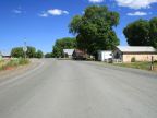
Unity has no grid of streets, most of the houses and buildings being built along the highway. U.S. Highway 26 passes through the town. East of town it turns south to cross El Dorado Pass into Malheur County. It turns north at the west end of town and heads into the Blue Mountains. The elevation is 4,000 feet, and the population was 131 at the 2000 census.
Street Index
|
a turnout Education Drive Federal Way First Avenue |
Job Creek Road Main Street South Fork Road |