Entry Points:

About Lake County
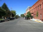
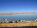
Lake County is named for the large and significant lakes in the county, Goose Lake, Summer Lake and Lake Abert. Summer Lake lies near the northwestern corner of the county, Goose Lake straddles the Oregon-California border to the south, and Lake Abert sits under the Abert Rim on the eastern edge. Lakeview, the county seat and largest town, lies close to Goose Lake. Basin and range topography describes the terrain of the county, with alternating valleys and mountain ranges running north to south, formed by faulting of the earths crust. The Abert Rim is said to be the largest fault scarp in the United States, with a vertical displacement of 2,000 feet, and thirty miles in length.
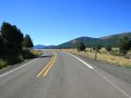
Lake County is part of what is known as the Oregon Outback country. Miles of sagebrush-covered desert occupy the northeastern part of the county, with forested mountains along the western border and both sides of the valley of Goose Lake.
Lake County was organized on October 24, 1874 with its county seat at Klamath Falls, which was then named Linkville. The county seat was moved to Lakeview in 1875 and in 1882, the area around Klamath Falls was separated to form Klamath County. In 1885 a portion of what was Grant County, to the east of Lakeview, was added to Lake County.
The population of Lake County was 7,422 at the 2000 census. U.S. Highway 395 is the major north-south route through the county. Oregon Highway 140 crosses the southern part of the county east to west. Oregon Highway 31 begins at Valley Falls, near the center of the county, and heads northwest.
For More Informationwww.LakeCountyOr.org is Lake County's official site. See also Wikipedia's Lake County article.