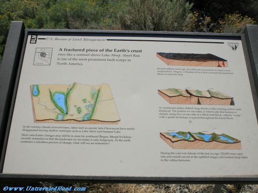
A fractured piece of the Earth's crust
rises like a sentinel above Lake Abert. Abert Rim
is one of the most prominent fault scarps in
North America.
Several million years ago, lava flowed across most of what is now
southeastern Oregon. A blanket of lava flows several thousand feet
thick covered the land.
As continental plates shifted, huge blocks of the existing surface were
displaced. The pattern we see today at Abert Lake that features a
sharply rising face on one side of a tilted fault block, called a "scarp",
with a gentle backslope is typical throughout the Great Basin.
During the cool wet climate of the last ice age, (20,000 years ago)
rain and ruoff carved at the uplifted ranges and formed deep lakes
in the valleys between.
In the warmer climate of recent times, lakes such as ancient lake Chewaucan have nearly
disappeared leaving shallow remnants such as Lake Abert and Summer Lake.
More cataclysmic changes may still be in store for southeast Oregon. Mount St Helens
recently reminded us that the landscape we see today is only temporary. As the earth
continues a relentless process of change, what will we see tomorrow?