Entry Points:

About Lake Owyhee
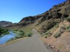
The Owyhee River drains a large area of desert and mountains in the area around the Oregon-Idaho-Nevada borders. It begins in Nevada and flows north into Idaho, skirts the south end of the Owyhee Mountains and crosses into Oregon where it loops around in a deep canyon and finally flows into the Snake River. Much of the country it passes through is volcanic, and it’s canyon walls are lined with colored volcanic rock.
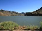
In 1932, the Owyhee Dam was built on the lower part of the river, creating Lake Owyhee. Lake Owyhee is 52 miles long, making it Oregon’s largest reservoir, and covers 13,900 acres. It is operated as a state park and is a popular resort for boating and fishing. A paved road connects from Oregon Highway 201 to the lake, taking a winding path up the gorge for several miles.
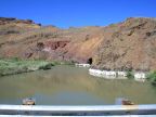
Owyhee Dam is a large concrete structure about 300 feet tall. The elevation of the water’s surface is 2,655 feet.
For More Information:
See the Wikipedia article on the Owyhee River.
Street Index
|
a dirt road a path a turnout Lake Owyhee |
Owyhee Dam Owyhee Lake Road Owyhee River |