Entry Points:

About Malheur County
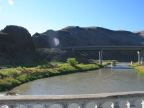
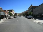
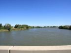
Malheur County was created on February 17, 1887, with 9,930 square miles of mountainous grassland in the southeast corner of Oregon. The Snake River passes along the northeast corner of the county, and lowlands along the river provide a fertile farmland. Most of the county's 31,615 residents live in this area. The county’s largest city, Ontario, is found here. The Malheur River, for which the county is named, crosses the through center of the county from the west to east, where it joins the Snake River near Ontario. Vale, the county seat, lies in one of the valleys along the Malheur River.
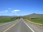
In the mid-1800s, thousands of settlers passed through Malheur County, fallowing the Oregon Trail. Interstate 84 passes through the same area now. U.S. Highways 20 and 26 cross the county from east to west, sharing a common route at the crossing of the Snake River, then splitting at Vale. Highway 20 follows the Malheur River, while Highway 26 turns northward. U.S. Highway 95 passes through the southern part of the county, coming from Nevada to the south, and passing into to Idaho to the east.
Malheur County is predominantly very arid, and vegetation is generally very sparse. Irrigation water makes farming possible along the rivers. Onions, sugar beets, corn and alfalfa are common crops.
The name Malheur originated with the early trapper Peter Skene Ogden who gave it this name on the occasion of his losing his cache of furs. The name is French for “misfortune.”
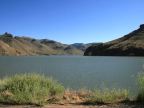
Lake Owyhee:
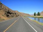
Lake Owyhee is one of the most popular tourist destinations in Malheur County, located in the hills several miles southwest of Nyssa. This large reservoir is fed by the Owyhee River and is surrounded by colorful cliffs of volcanic rock. It is a popular retreat for boating. A scenic drive along the the Owyhee River brings you to the lake.
For More Information:
See Malheur County’s official website, www.malheurco.org. See also Wikipedia, Malheur County, Oregon.