Entry Points:

About Nyssa
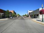
Nyssa was settled on the Oregon trail where it crossed the Snake River. It became a shipping center for livestock as it was on the main line of the Union Pacific Railroad. In 1935 the Amalgamated Sugar Company built a factory for processing sugar from beets grown in the area which employed as many as 600 people. The factory closed in 2005, dealing a blow to the local economy.
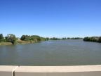
The Snake River, which is as wide as a city block, flows from south to north past Nyssa on the east side of town. It forms the eastern border of Oregon in this area. To the south it makes a bend to the east, and it flows all the way across southern Idaho, originating in Yellowstone National Park in Wyoming. To the north it flows through Hells Canyon and eventually joins the Columbia River.
Nyssa is located in the Treasure Valley area of Oregon, an agricultural region along the Snake River. Farmland stretches for miles in every direction and vast crops of corn, wheat, beets, onions and other crops are produced.
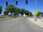
Nyssa is on the route of the combined U.S. Highway 20 and 26. Heading east it crosses into Idaho, and intersects with U.S. Highway 95 just a mile beyond the river. From there it turns south and leads to Parma, which is the site of the original Fort Boise of the Oregon Trail. On the west side of Nyssa, it turns north, and eventually reaches Vale in the Malheur River Valley. State Highway 210 also leaves Nyssa heading west, and then south, towards Adrian.
The population of Nyssa was 3,163 at the 2000 census. The elevation at the river is about 2,170 feet with a gentle rise towards the west. The name is pronounced with a short 'i' sound, 'niss-uh'.
For More Information:
See the Wikipedia article Nyssa, Oregon and the official city site at www.nyssacity.org.