Entry Points:

About Vale
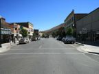
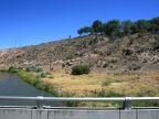
Vale was the first stop in Oregon on the Oregon Trail. It sits at the edge of a valley of irrigated farmland next to the Malheur River and at the base of some hills. Old brick buildings line the streets in the downtown area. Farmland fills the valley floor north of Vale and to the east and west from there. A sign near Vale boasts that thousands of truckloads of onions are produced every year in the area. The hills surrounding Vale are very arid and are usually covered in yellow, dried grass.
U.S. Highways 20 and 26 meet at Vale. Highway 20 comes from the southwest and highway 26 comes from the northwest. They combine on the east end of Vale and head eastward. Lytle Boulevard, a rural road, heads south out of Vale following the route of the Oregon Trail over the hills and down towards the Snake RIver on the other side.
Vale is known for its many murals painted on the walls of buildings depicting Oregon Trail scenes. The population of Vale was 1,976 in the year 2000 and it sits at 2,242 feet in elevation. It is the county seat of Malheur County.
For More Information:
Wikipedia has an article on Vale. Read about the murals in Vale at ValeOregonMurals.com.