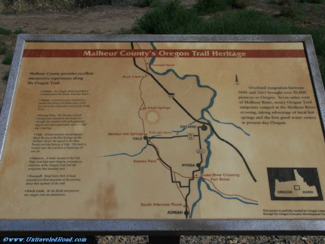
Malheur County's Oregon Trail Heritage
Overland emigration between
1840 and 1863 brought over 50,000
pioneers to Oregon. Seven miles west
of Malheur Butte, weary Oregon Trail
emigrants camped at the Malheur River
crossing, taking advantage of local hot
springs and the first good water source
in present-day Oregon.
Malheur County provides excellent
interpretive experiences along
the Oregon Trail:
• Adrian. An Oregon Historical Marker
commemorates the South Alternate Route.
• Nyssa. A kiosk presents interpretive
panels describing Fort Boise and a visual
account of the emigrants crossing the Snake
River.
• Keeney Pass. The Bureau of Land
Management interprets the dusty trek
through the summit with well-preserved
wagon ruts and a panoramic view of a full
day's journey.
• Vale. A kiosk presents interpretation
about the use of the Hot Springs on the
Malheur River, the legend of the Blue
Bucket and the history of Vale. The kiosk is
located near the juction of Highways 20 and 26.
• Ontario. A kiosk, located at the I-84
Rest Area East near Ontario, presents an
overview of the Oregon Trail and the
emigrants that traveled west.
• Farwell. Bend State Park. A kiosk
presents excellent accounts of the journey
along this segment of the trail.
• Birch Creek. At the BLM interpretative
site, wagons ruts are distinctive.