Entry Points:

About Drewsey
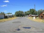
The tiny cowboy town Drewsey is located a couple miles off U.S. Highway 20 near the Malheur River in Drewsey Valley. The valley stretches along the river for several miles, being less than a mile wide in most places. Grassland and hay fields fill the valley, bounded by hills covered in sage brush and junipers, with jagged lava rock formations which frequently protrude from the hills.
Drewsey was settled by Abner Robbins in 1883, who built a store here. He named it “Gouge Eye,” a name which wasn't accepted by the postal service. He then tried the name “Drusy” which the postal service changed to “Drewsey.” The elevation is 3,510 feet, and the population is reported in Wikipedia to be 18.
The Malheur River passes by Drewsey on the north side. It has it's source in Logan Valley not far to the northwest and flows eastward into the Snake River, being one of the major rivers of eastern Oregon. It provides irrigation water which Drewsey depends on.
Drewsey occupies an isolated spot in the barren hills of eastern Oregon. The nearest town is Juntura, a small town a ways to the east. To reach a town of even a few thousand people, an hour's drive will bring you to Burns or Vale.
For More Information:
See the article in Wikipedia on Drewsey, Oregon.
Street Index
|
A Street Drewsey Road Drewsey Street First Street |
Market Lane Second Street Third Street |